TerraClear Launches Commercial Weed Mapping for Corn and Soybeans, Bringing Quarter-Inch Detection to the Sprayer
ISSAQUAH, Wash., Aug. 25, 2026

Press Release Disclaimer: This is a press release distributed through the XPR Media network. It has not been independently verified by our newsroom.

TerraClear Launches Commercial Weed Mapping for Corn and Soybeans, Bringing Quarter-Inch Detection to the Sprayer
PR Newswire
ISSAQUAH, Wash., Aug. 25, 2026
Full-field imagery — every acre, not a sample — delivered as a sprayer-ready map the next day
ISSAQUAH, Wash., Aug. 25, 2026 /PRNewswire/ — TerraClear has announced the commercial availability of its weed mapping solution for corn and soybeans, extending the field-intelligence platform it has used to map more than 1.5 million acres into one of the costliest problems in row-crop agriculture: weed control.
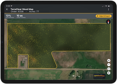
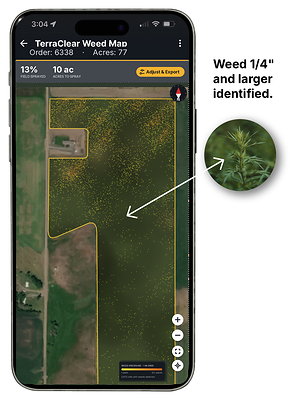
TerraClear Weed Maps identify individual weeds as small as a quarter inch, built from imagery captured at 1.5-millimeter resolution across the entire field. Each map is delivered as a georeferenced prescription that uploads directly to section/nozzle controlled sprayers, allowing growers and applicators to act at the nozzle level rather than treating whole fields or broad zones. RTK positioning ties every detection to a real-world coordinate, so the sprayer turns on where a weed actually is — and stays off where it isn’t.
TerraClear introduced weed maps alongside new stand count maps for corn and soybeans in July, and is now taking acre commitments ahead of the 2027 crop season.
Built on a platform already proven at scale
TerraClear’s weed mapping runs on the same mapping and machine-learning pipeline the company built for field rock detection — the technology behind more than 1.5 million acres of rock maps delivered to over 1,000 farm operations. The hard parts of high-resolution field intelligence, including full-field imagery capture, ground-truth accuracy and geospatial precision, were solved before the first weed map was produced.
“We spent years learning how to find a rock the size of a fist in a 160-acre field and put a machine on it within a few inches,” said Devin Lammers, CEO of TerraClear. “Once you can do that reliably, at scale, and at a price a grower will actually pay, weeds are the natural next problem. The map is the product. It’s what turns a sprayer from a broadcast tool into a targeting tool.”
What makes a map usable instead of just viewable
Three things separate a map a grower can spray versus a map a grower can only look at: whether it covers the whole field, whether it resolves plants small enough to matter, and whether it arrives while the grower can still act.
The whole field. TerraClear images every acre. Coverage is wall-to-wall rather than sampled, so the prescription reflects the actual distribution of weeds — including the field edges, waterways, headlands and problem corners where escapes concentrate and where sampled approaches are most likely to miss. Nothing is interpolated between scouting points. Complete coverage is a logistics problem as much as a sensing one, and TerraClear regularly images more than 1,000 acres per day in favorable weather conditions — the throughput required to cover a real operation, not a demonstration field.
Resolution to see small plants. Imagery at 1.5-millimeter resolution resolves individual weeds down to a quarter inch. That threshold is agronomic, not cosmetic: post-emergence control is most effective, and most economical, on small weeds. A map that finds a weed only once it is six inches tall has already missed the window that mattered.
Arrival in the usable window. Maps are returned on average the next day from image collection. In-season weed pressure changes fast, and a prescription that arrives a week late describes a field that no longer exists.
Lammers said meeting all three conditions at once is what makes the product operational rather than academic. “A sample tells you a field probably has a problem. Full-field imagery at a quarter inch tells you exactly where it is, while the weeds are still small enough to kill cheaply. Growers don’t buy resolution, they buy outcomes — fewer acres sprayed, more efficacy for the same dollar, cleaner fields, and a record of what was actually out there.”
What growers get
- Full-field coverage — every acre imaged, wall to wall, with no sampling or interpolation
- Field-scale throughput — regularly more than 1,000 acres per day in favorable weather
- 24-hour turnaround from image collection to sprayer-ready map
- Weed maps for corn and soybeans with detection down to a quarter inch
- Stand count maps for early-season emergence and population assessment
- Sprayer-ready outputs for nozzle-level control on modern precision equipment
- RTK-grade geo-positioning for repeatable, in-season accuracy
- A durable field record for agronomic decisions, resistance management and year-over-year comparison
- Two ways to buy — Mapping-as-a-Service per acre, or hardware plus subscription for in-house collection
Availability and how to buy
Weed and stand count maps for corn and soybeans are available now, with acre commitments being accepted for the 2027 crop season.
TerraClear offers two commercial paths to the same maps. Under Mapping-as-a-Service, TerraClear handles imagery collection and map delivery on a per-acre basis, so a grower can adopt targeted application without new capital equipment beyond the sprayers many already operate. Operations that would rather control their own collection timing and scale can license the platform through a hardware-plus-subscription option. Both paths produce identical map outputs in the same sprayer-ready formats.
Growers, custom applicators and retailers interested in reserving acres can contact TerraClear at TerraClear.com or sales@terraclear.com / 712-513-2809.
About TerraClear
TerraClear builds field intelligence and robotics that remove the hardest, most repetitive work from broadacre farming. Founded in 2017 and headquartered in Issaquah, Washington, with operations in Grangeville, Idaho; Parkersburg, Iowa; and Sioux Falls, South Dakota, TerraClear has mapped more than 1.5 million acres for growers and custom operators across the U.S. Learn more at TerraClear.com.

 View original content to download multimedia:https://www.prnewswire.com/news-releases/terraclear-launches-commercial-weed-mapping-for-corn-and-soybeans-bringing-quarter-inch-detection-to-the-sprayer-302858882.html
SOURCE TerraClear